
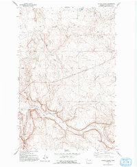
1968 Map of Foster Coulee
USGS Topo · Published 1971About this map
Foster Coulee cuts a deep path through the Douglas County landscape, serving as the dominant geographic feature of this high plateau region. The 1968 field check reveals a terrain primarily defined by natural drainage and geological formations rather than dense settlement. Water sources like Elbow Lake, Clear Lake, and Buck Lake punctuate the northern sections, while Foster Creek and its southern branch, East Foster, wind through the lower coulee floor. The land use appears focused on extraction and utility, indicated by several scattered wells and sites like the Borrow Pit and Gravel Pit. The presence of Tower Rock provides a distinct vertical landmark in an area otherwise characterized by sweeping elevation changes and the carved channel of the coulee itself, reflecting the geological processes that shaped the Columbia Plateau.
Find a feature on this map
14 named features on this map. Tap any name to fly to it.
Don’t see what you’re looking for? This feature index may not catch every label — zoom into the map to look around manually.
Map Details
Editions of this 1968 Foster Coulee Map
2 editions found
Other maps of this area

1950 · Boot Mtn
USGS Topo · 1:62,500

1950 · Alameda Flat
USGS Topo · 1:62,500

1952 · Alameda Flat
USGS Topo · 1:62,500

1953 · Ritzville
USGS Topo · 1:250,000

1954 · Okanogan
USGS Topo · 1:250,000

1958 · Okanogan
USGS Topo · 1:250,000

1959 · Ritzville
USGS Topo · 1:250,000

1965 · Ritzville
USGS Topo · 1:250,000

1968 · Steamboat Rock SW
USGS Topo · 1:24,000

1968 · Barker Canyon
USGS Topo · 1:24,000