
1968 Map of Foster Coulee
USGS Topo · Published 1993About this map
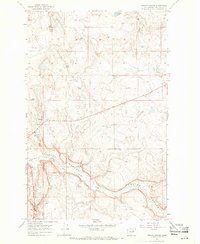
Foster Coulee dominates this Douglas County landscape, a deep geological incision that carves through the basalt plateau. Based on data from the late 1960s, the map reveals a sparsely populated region defined by its hydrography and resource extraction. Significant water bodies such as Elbow Lake, Buck Lake, and Clear Lake dot the upper elevations, providing essential focal points in an otherwise arid terrain. The lower elevations follow the meandering path of Foster Creek as it winds through the coulee floor.
Find a feature on this map
16 named features on this map. Tap any name to fly to it.
Don’t see what you’re looking for? This feature index may not catch every label — zoom into the map to look around manually.
Map Details
Editions of this 1968 Foster Coulee Map
2 editions found
Historical Maps of Douglas County Through Time
65 maps found

1912 Malaga
Douglas County, WA

1914 Malaga
Douglas County, WA

1965 Jameson Lake East
Douglas County, WA

1965 Jameson Lake SE
Douglas County, WA

1965 Jameson Lake SW
Douglas County, WA

1965 Jameson Lake West
Douglas County, WA

1965 Mold
Douglas County, WA

1965 St. Andrews
Douglas County, WA

1966 Malaga NE
Douglas County, WA

1966 Palisades
Douglas County, WA

1966 Rattlesnake Springs
Douglas County, WA

1966 Rock Island Dam
Douglas County, WA

1968 Alstown
Douglas County, WA

1968 Barker Canyon
Douglas County, WA

1968 Barnes Butte
Douglas County, WA

1968 Chief Joseph Dam
Douglas County, WA

1968 Coleman Hill
Douglas County, WA

1968 Douglas
Douglas County, WA

1968 Farmer
Douglas County, WA
1968 Foster Coulee
Douglas County, WA

1968 Lamoine
Douglas County, WA

1968 Leahy
Douglas County, WA

1968 Mud Spring
Douglas County, WA

1968 Orondo
Douglas County, WA

1968 Piersol Hills
Douglas County, WA

1968 Sims Corner
Douglas County, WA

1968 Wells Dam
Douglas County, WA

1968 Withrow
Douglas County, WA

1980 Trefry Canyon
Douglas County, WA

1981 Stubblefield Point
Douglas County, WA

1985 Sagebrush Flat
Douglas County, WA

1989 Alameda Flat
Douglas County, WA

1989 Sanderson Creek
Douglas County, WA

2003 Orondo
Douglas County, WA

2023 Alameda Flat
Douglas County, WA

2023 Alstown
Douglas County, WA

2023 Barker Canyon
Douglas County, WA

2023 Barnes Butte
Douglas County, WA

2023 Chief Joseph Dam
Douglas County, WA

2023 Coleman Hill
Douglas County, WA

2023 Douglas
Douglas County, WA

2023 Farmer
Douglas County, WA

2023 Foster Coulee
Douglas County, WA

2023 Jameson Lake East
Douglas County, WA

2023 Jameson Lake SE
Douglas County, WA

2023 Jameson Lake SW
Douglas County, WA

2023 Jameson Lake West
Douglas County, WA

2023 Lamoine
Douglas County, WA

2023 Leahy
Douglas County, WA

2023 Malaga NE
Douglas County, WA

2023 Mold
Douglas County, WA

2023 Mud Spring
Douglas County, WA

2023 Orondo
Douglas County, WA

2023 Palisades
Douglas County, WA

2023 Piersol Hills
Douglas County, WA

2023 Rattlesnake Springs
Douglas County, WA

2023 Rock Island Dam
Douglas County, WA

2023 Sagebrush Flat
Douglas County, WA

2023 Saint Andrews
Douglas County, WA

2023 Sanderson Creek
Douglas County, WA

2023 Sims Corner
Douglas County, WA

2023 Stubblefield Point
Douglas County, WA

2023 Trefry Canyon
Douglas County, WA

2023 Wells Dam
Douglas County, WA

2023 Withrow
Douglas County, WA