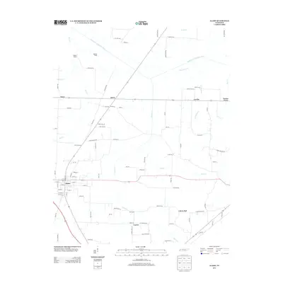
2013 Map of Alamo
USGS Topo · Published 2013About this map
The Middle Fork Forked Deer River meanders across the northern portion of this landscape, defining the rural character of Crockett County. The town of Alamo serves as the central hub, with a street grid including W Main St and E Main St branching out toward surrounding agricultural communities. Nearby, several smaller settlements and crossroads like Quincy, Coxville, and Porters Grove are connected by a network of local roads such as Quincy Rd and Raleigh Bird Rd. To the north, distinctive terrain features like Horns Bluff and Mound Field overlook the river valley. The southern area is marked by Cypress Cr and the localities of Cypress and Liberty Hall, illustrating the distributed settlement patterns common in this part of Tennessee. These details offer a clear view of the county's geographic layout and its rural infrastructure at the start of the 2010s.
Find a feature on this map
90 named features on this map. Tap any name to fly to it.
Don’t see what you’re looking for? This feature index may not catch every label — zoom into the map to look around manually.
Map Details
Editions of this 2013 Alamo Map
This is the sole edition of this map. No revisions or reprints were ever made.
Other maps of this area

1951 · Trenton
USGS Topo · 1:24,000

1956 · Blytheville
USGS Topo · 1:250,000

1959 · Blytheville
USGS Topo · 1:250,000

1959 · Bells
USGS Topo · 1:24,000

1959 · Adair
USGS Topo · 1:24,000

1959 · Humboldt
USGS Topo · 1:24,000

1961 · Jones
USGS Topo · 1:24,000
1964 · Maury City
USGS Topo · 1:24,000
1964 · Alamo
USGS Topo · 1:24,000
1964 · Brazil
USGS Topo · 1:24,000