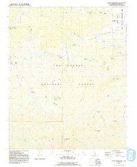
1991 Map of Alamo Mountain
USGS Topo · Published 1991About this map
Los Padres National Forest contains a complex network of high-elevation peaks and remote drainage basins, where water and mineral access dictated the few points of human habitation. Named peaks such as Alamo Mountain, McDonald Peak, and Stewart Mountain dominate the skyline, while deep canyons like Maxy Canyon and Bear Gulch funnel seasonal runoff toward Piru Creek. The landscape is dotted with the remnants of earlier extraction and settlement efforts, represented by the Harris Mine and Castaic Mine, along with several historic locations noted as sites, including Schmidt Ranch and Harris Mill.
Find a feature on this map
58 named features on this map. Tap any name to fly to it.
Don’t see what you’re looking for? This feature index may not catch every label — zoom into the map to look around manually.
Map Details
Editions of this 1991 Alamo Mountain Map
2 editions found
Other maps of this area

1903 · Mt. Pinos
USGS Topo · 1:125,000

1903 · Tejon
USGS Topo · 1:125,000

1933 · Gorman
USGS Topo · 1:24,000

1938 · Gorman
USGS Topo · 1:24,000

1938 · Black Mountain
USGS Topo · 1:24,000

1942 · Frazier Mountain
USGS Topo · 1:24,000

1943 · Topatopa Mountains
USGS Topo · 1:24,000

1943 · Cuddy Valley
USGS Topo · 1:24,000

1943 · Lockwood Valley
USGS Topo · 1:24,000
1943 · Devils Heart Peak
USGS Topo · 1:24,000