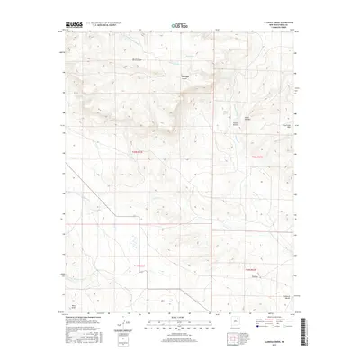
2017 Map of Alamosa Creek
USGS Topo · Published 2017About this map
Alamosa Creek winds through the canyons of northeastern New Mexico, defining a landscape marked by complex drainage networks and traditional land partitions. The area is characterized by dramatic topographic features such as Las Mesas Del-Conjelon and the high ridges of the Cuernudo Hills. Water is the primary architect of this terrain, evident in the numerous named draws and canyons like Bootlegger Canyon, Cañon Bonito, and Cañon Cuevitas. Local ranchers and land managers have long relied on scattered water sources such as MacArthur Tank, Mayes Spring, and Bootlegger Spring to sustain activity in this arid environment. The map shows the convergence of several major drainages, including Carrizo Cr and Vermejo Cr, which feed into the larger creek system. Historically, these named canyons and springs often served as vital landmarks for travel and livestock grazing across the high plains and mesa country.
Find a feature on this map
22 named features on this map. Tap any name to fly to it.
Don’t see what you’re looking for? This feature index may not catch every label — zoom into the map to look around manually.
Map Details
Editions of this 2017 Alamosa Creek Map
This is the sole edition of this map. No revisions or reprints were ever made.
Other maps of this area

1892 · Watrous
USGS Topo · 1:125,000

1894 · Watrous
USGS Topo · 1:125,000

1954 · Santa Fe
USGS Topo · 1:250,000

1954 · Raton
USGS Topo · 1:250,000

1958 · Raton
USGS Topo · 1:250,000

1958 · Santa Fe
USGS Topo · 1:250,000

1964 · Wagon Mound
USGS Topo · 1:24,000

1964 · Alto De Hormiga
USGS Topo · 1:24,000

1964 · Frutosa Lake
USGS Topo · 1:24,000

1964 · Mogote Hills
USGS Topo · 1:24,000