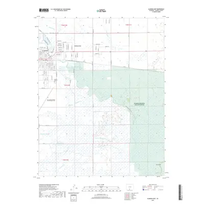
2019 Map of Alamosa East
USGS Topo · Published 2019About this map
The Rio Grande and the Alamosa River converge in a complex network of wetlands and man-made irrigation channels just east of Alamosa. This landscape is defined by its water management history, featuring an intricate system of laterals and ditches such as the Chicago Ditch, Maddux Ditch, and Seamans Ditch that support the surrounding agricultural valley. To the south and east, the Alamosa National Wildlife Refuge preserves the river bottomlands, while the prominent Hansen Bluff rises above the eastern plains.
Find a feature on this map
81 named features on this map. Tap any name to fly to it.
Don’t see what you’re looking for? This feature index may not catch every label — zoom into the map to look around manually.
Map Details
Editions of this 2019 Alamosa East Map
This is the sole edition of this map. No revisions or reprints were ever made.
Other maps of this area

1954 · Trinidad
USGS Topo · 1:250,000

1955 · Trinidad
USGS Topo · 1:250,000

1958 · Trinidad
USGS Topo · 1:250,000

1959 · Trinidad
USGS Topo · 1:250,000

1965 · Baldy
USGS Topo · 1:24,000

1965 · Lasauses
USGS Topo · 1:24,000

1965 · Dry Lakes
USGS Topo · 1:24,000
1966 · Mount Pleasant School
USGS Topo · 1:24,000
1966 · Hooper SE
USGS Topo · 1:24,000
1966 · Alamosa East
USGS Topo · 1:24,000