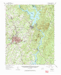
1957 Map of Albemarle
USGS Topo · Published 1966About this map
The Yadkin River and Pee Dee River corridor defines this mid-century landscape, dominated by the hydroelectric reservoirs of Badin Lake and Lake Tillery. At the heart of the region, the city of Albemarle shows significant post-war growth, featuring the Albemarle Airport, a Drive-in Theater, and two radio towers. Industrial and resource-extractive history is visible through the Coggins Mine near Eldorado and the infrastructure of the Badin Dam and Falls Dam.
Find a feature on this map
82 named features on this map. Tap any name to fly to it.
Don’t see what you’re looking for? This feature index may not catch every label — zoom into the map to look around manually.
Map Details
Editions of this 1957 Albemarle Map
2 editions found
Other maps of this area

1942 · Troy
USGS Topo · 1:125,000

1949 · High Rock
USGS Topo · 1:24,000

1953 · Raleigh
USGS Topo · 1:250,000

1953 · Charlotte
USGS Topo · 1:250,000

1954 · Charlotte
USGS Topo · 1:250,000

1954 · Raleigh
USGS Topo · 1:250,000

1956 · Mount Gilead East
USGS Topo · 1:24,000

1956 · Mount Gilead West
USGS Topo · 1:24,000

1957 · Mount Pleasant
USGS Topo · 1:62,500

1957 · Albemarle
USGS Topo · 1:62,500