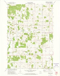
1972 Map of Albertville
USGS Topo · Published 1975About this map
The agrarian landscape of Howard, Tilden, and Wheaton townships is defined by the transition from earlier settlement patterns to modern infrastructure in the early 1970s. The map distinguishes between the main village of Albertville and the nearby Old Albertville, indicating a shift in the local center of gravity over time. This region is tied together by the Soo Line railroad and a grid of rural routes including Massey Road, Wheaton Road, and Hyline Road. Conservation efforts are prominent along the watercourses, specifically within the Elk Creek State Public Fishing Area, which protects the winding path of Elk Creek. Resource extraction is evident through several scattered Gravel Pits and Sandpits, while the presence of a Substation and a major Pipeline cutting across the townships reflects the area's role in the regional energy and utility network.
Find a feature on this map
29 named features on this map. Tap any name to fly to it.
Don’t see what you’re looking for? This feature index may not catch every label — zoom into the map to look around manually.
Map Details
Editions of this 1972 Albertville Map
This is the sole edition of this map. No revisions or reprints were ever made.
Other maps of this area

1934 · Elk Mound
USGS Topo · 1:62,500

1934 · Chippewa Falls
USGS Topo · 1:62,500

1936 · Chippewa Falls
USGS Topo · 1:62,500

1936 · Elk Mound
USGS Topo · 1:62,500

1949 · Bloomer
USGS Topo · 1:62,500

1949 · New Auburn
USGS Topo · 1:62,500

1951 · Bloomer
USGS Topo · 1:62,500

1951 · New Auburn
USGS Topo · 1:62,500

1953 · Eau Claire
USGS Topo · 1:250,000

1953 · Rice Lake
USGS Topo · 1:250,000