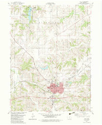
1982 Map of Albia
USGS Topo · Published 1983About this map
The Monroe County seat of Albia serves as the central hub of this early 1980s Iowa landscape, characterized by a complex intersection of major rail lines including the Burlington Northern, Norfolk and Western, and Chicago and North Western. This convergence of heavy rail infrastructure surrounding the town and the smaller settlement of Maxon highlights the region's importance as a transportation corridor for agricultural and industrial goods. Beyond the urban grid, the map reveals a meticulously documented rural landscape dotted with local landmarks like the Monroe County Fairground and the O'Brien Landing Strip. Significant recreational and conservation areas are visible to the north, most notably the Miami Lake State Game Management Area and Miami Lake, which provide a contrast to the surrounding agricultural townships of Troy and Bluff Creek.
Find a feature on this map
46 named features on this map. Tap any name to fly to it.
Don’t see what you’re looking for? This feature index may not catch every label — zoom into the map to look around manually.
Map Details
Editions of this 1982 Albia Map
This is the sole edition of this map. No revisions or reprints were ever made.
Other maps of this area

1929 · Albia
USGS Topo · 1:62,500

1939 · Mystic
USGS Topo · 1:62,500

1942 · Mystic
USGS Topo · 1:62,500

1954 · Centerville
USGS Topo · 1:250,000

1954 · Des Moines
USGS Topo · 1:250,000

1956 · Des Moines
USGS Topo · 1:250,000

1957 · Des Moines
USGS Topo · 1:250,000

1957 · Centerville
USGS Topo · 1:250,000

1958 · Centerville
USGS Topo · 1:250,000

1968 · Eddyville
USGS Topo · 1:24,000