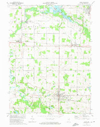
1973 Map of Albion
USGS Topo · Published 1974About this map
The town of Albion serves as the focal point of this mid-1970s survey, showing its development around the Baltimore and Ohio railroad line. The landscape is a network of agricultural fields and water bodies, most notably the Elkhart River system which connects Waldron Lake, Steinbarger Lake, and Tamarack Lake in the north. Notable local landmarks include the Central Noble High Sch, the County Home, and the Rose Hill Cem on the outskirts of the village.
Find a feature on this map
44 named features on this map. Tap any name to fly to it.
Don’t see what you’re looking for? This feature index may not catch every label — zoom into the map to look around manually.
Map Details
Editions of this 1973 Albion Map
This is the sole edition of this map. No revisions or reprints were ever made.
Other maps of this area

1947 · Wolcottville
USGS Topo · 1:24,000

1947 · Oliver Lake
USGS Topo · 1:24,000

1951 · Ormas
USGS Topo · 1:24,000

1951 · Merriam
USGS Topo · 1:24,000

1953 · Fort Wayne
USGS Topo · 1:250,000

1955 · Ege
USGS Topo · 1:24,000

1955 · Kendallville
USGS Topo · 1:24,000

1956 · Fort Wayne
USGS Topo · 1:250,000

1956 · Ligonier
USGS Topo · 1:24,000

1956 · Albion
USGS Topo · 1:24,000