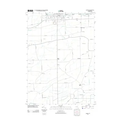
2013 Map of Albion
USGS Topo · Published 2013About this map
The Erie Canal cuts through the northern edge of this landscape, defining the layout of Albion with a network of crossings including the Ingersoll Street Bridge and Brown Street Bridge. Beyond the village, the terrain shifts into a productive agricultural pattern of orchards and mucklands. Named family operations like Panek Farms, Culhanes Tree Farm, and Angevine Farms are interspersed with smaller hamlets such as Richs Corners and Barre Center. The map is particularly rich in genealogical data, recording numerous burial grounds like Mt Albion Cem, Saint Josephs Cem, and the small Love Cem to the east. Waterways such as Otter Cr and W Br Sandy Cr wind through the fields, while the southern reaches are marked by the unique drainage of Manning Muckland Creek, reflecting the specialized peat-soil farming that has long characterized this portion of Orleans County.
Find a feature on this map
96 named features on this map. Tap any name to fly to it.
Don’t see what you’re looking for? This feature index may not catch every label — zoom into the map to look around manually.
Map Details
Editions of this 2013 Albion Map
This is the sole edition of this map. No revisions or reprints were ever made.
Other maps of this area

1897 · Albion
USGS Topo · 1:62,500

1897 · Medina
USGS Topo · 1:62,500

1897 · Oak Orchard
USGS Topo · 1:62,500

1897 · Ridgeway
USGS Topo · 1:62,500

1944 · Holley
USGS Topo · 1:31,680

1944 · Byron
USGS Topo · 1:31,680

1944 · Ashwood
USGS Topo · 1:31,680

1944 · Albion
USGS Topo · 1:31,680

1949 · Kendall
USGS Topo · 1:62,500
1950 · Knowlesville
USGS Topo · 1:24,000