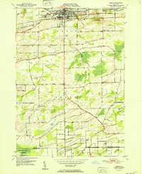
1952 Map of Albion
USGS Topo · Published 1952About this map
The Erie Canal anchors the northern landscape of this Orleans County survey, where the village of Albion serves as a center of commerce and transport. The New York Central railroad runs parallel to the waterway, underscoring the era's reliance on these vital transit corridors. Just west of the village, the State Training School for Girls occupies a significant campus, while the County Fairgrounds and County Hospital mark the outskirts of the settlement. To the south, the terrain of Barre is defined by a network of rural hamlets including Barre Center, East Barre, and South Barre. This area shows a pattern of early 20th-century agriculture and localized industry, evidenced by the Spoil Banks near the Elba town line and the presence of family-named landmarks such as Richs Corners and Braggs Corners. Historically significant burial sites, including the expansive Mt Albion Cem and the smaller Allis Cem, are clearly delineated alongside drainage systems like Otter Creek and the Oak Orchard Swamp.
Find a feature on this map
54 named features on this map. Tap any name to fly to it.
Don’t see what you’re looking for? This feature index may not catch every label — zoom into the map to look around manually.
Map Details
Editions of this 1952 Albion Map
This is the sole edition of this map. No revisions or reprints were ever made.
Other maps of this area

1897 · Albion
USGS Topo · 1:62,500

1897 · Medina
USGS Topo · 1:62,500

1897 · Oak Orchard
USGS Topo · 1:62,500

1897 · Ridgeway
USGS Topo · 1:62,500

1944 · Holley
USGS Topo · 1:31,680

1944 · Byron
USGS Topo · 1:31,680

1944 · Ashwood
USGS Topo · 1:31,680

1944 · Albion
USGS Topo · 1:31,680

1949 · Kendall
USGS Topo · 1:62,500
1950 · Knowlesville
USGS Topo · 1:24,000