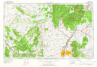
1963 Map of Albuquerque
USGS Topo · Published 1965About this map
Albuquerque and the surrounding high desert terrain are documented here during a period of significant mid-century growth. The map illustrates a complex network of traditional settlements, such as San Felipe Pueblo and Santo Domingo Pueblo, situated alongside modern defense installations like Kirtland AFB and the Sandia Military Reservation. This 1963 survey captures the region's diverse landscape, from the volcanic features of the Valles Caldera and the massive Sandia Mountains to the mining activity at the Ortiz Mine.
Find a feature on this map
221 named features on this map. Tap any name to fly to it.
Don’t see what you’re looking for? This feature index may not catch every label — zoom into the map to look around manually.
Map Details
Editions of this 1963 Albuquerque Map
3 editions found
Other maps of this area

1883 · Mt. Taylor
USGS Topo · 1:250,000

1886 · Wingate
USGS Topo · 1:250,000

1886 · Mt. Taylor
USGS Topo · 1:250,000

1888 · Bernalillo
USGS Topo · 1:125,000

1889 · Albuquerque
USGS Topo · 1:125,000

1889 · Largo
USGS Topo · 1:250,000

1889 · Chaco
USGS Topo · 1:250,000

1889 · Santa Fe
USGS Topo · 1:125,000

1890 · Jemes
USGS Topo · 1:125,000

1892 · San Pedro
USGS Topo · 1:125,000