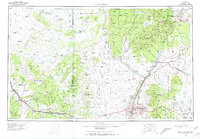
1963 Map of Albuquerque
USGS Topo · Published 1971About this map
Mount Taylor dominates the western horizon of this mid-century New Mexico landscape, a region defined by high mesas and the transition from the Chaco Divide to the Rio Grande valley. The map documents the mid-century infrastructure of the Rio Grande corridor, including the extensive operations at Kirtland AFB and the adjacent Sandia Military Reservation. To the west, the mining and ranching economy is evident near Grants and Milan, while the remote northern reaches show a network of trading posts such as Seven Lakes Trading Post and Star Lake Trading Post that served the sprawling high desert.
Find a feature on this map
205 named features on this map. Tap any name to fly to it.
Don’t see what you’re looking for? This feature index may not catch every label — zoom into the map to look around manually.
Map Details
Editions of this 1963 Albuquerque Map
3 editions found
Other maps of this area

1883 · Mt. Taylor
USGS Topo · 1:250,000

1886 · Wingate
USGS Topo · 1:250,000

1886 · Mt. Taylor
USGS Topo · 1:250,000

1888 · Bernalillo
USGS Topo · 1:125,000

1889 · Albuquerque
USGS Topo · 1:125,000

1889 · Largo
USGS Topo · 1:250,000

1889 · Chaco
USGS Topo · 1:250,000

1889 · Santa Fe
USGS Topo · 1:125,000

1890 · Jemes
USGS Topo · 1:125,000

1892 · San Pedro
USGS Topo · 1:125,000