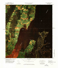
1977 Map of Alburg Springs Station
USGS Topo · Published 1978About this map
The international border between Vermont and Quebec bisects this landscape of wetlands and water where Missisquoi Bay meets the northern reaches of Lake Champlain. The crossing at Alburg Springs Station U. S. Customs and Clarenceville Canadian Customs serves as a vital transit point between nations, while the Missisquoi Bay Bridge links the western shore to West Swanton. The terrain is characterized by a complex network of waterways, including the Missisquoi River and its East Branch and West Branch, which feed into Gander Bay and Goose Bay. Industrial and transport patterns are defined by the Canadian National Railroad and the Central Vermont Railroad, which navigate the low-lying areas near East Alburg. Significant landforms like Hog Island and Metcalfe Island rise above the marshy sloughs, reflecting the region's glacial legacy.
Find a feature on this map
45 named features on this map. Tap any name to fly to it.
Don’t see what you’re looking for? This feature index may not catch every label — zoom into the map to look around manually.
Map Details
Editions of this 1977 Alburg Springs Station Map
This is the sole edition of this map. No revisions or reprints were ever made.
Other maps of this area

1895 · Rouse Point
USGS Topo · 1:62,500

1907 · Rouse Point
USGS Topo · 1:62,500

1914 · St. Albans
USGS Topo · 1:48,000

1916 · St. Albans
USGS Topo · 1:62,500

1939 · Rouses Point
USGS Topo · 1:62,500

1943 · Rouses Point
USGS Topo · 1:62,500

1943 · St. Albans
USGS Topo · 1:62,500

1950 · Lake Champlain
USGS Topo · 1:250,000

1956 · Rouses Point
USGS Topo · 1:62,500

1958 · Lake Champlain
USGS Topo · 1:250,000