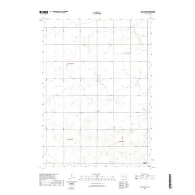
2017 Map of Alcester NW
USGS Topo · Published 2017About this map
Norway Center serves as a primary reference point in this corner of Lincoln County, where the landscape is defined by the drainage of several prairie streams. The area is marked by the winding paths of Saddle Cr and W Brule Cr, which cut through the agricultural sections and section lines. Genealogists and local historians will find the locations of Tuntland Cem and Romsdal Cem particularly significant, as these burial grounds represent the enduring legacy of early Scandinavian settlement in this part of South Dakota. The map captures a grid of rural roads, including Co HWY 140 and Co HWY 146, that connect isolated farmsteads and manage the flow of travel through the township sections.
Find a feature on this map
27 named features on this map. Tap any name to fly to it.
Don’t see what you’re looking for? This feature index may not catch every label — zoom into the map to look around manually.
Map Details
Editions of this 2017 Alcester NW Map
This is the sole edition of this map. No revisions or reprints were ever made.
Other maps of this area

1897 · Canton
USGS Topo · 1:125,000

1900 · Canton
USGS Topo · 1:125,000

1955 · Sioux Falls
USGS Topo · 1:250,000

1958 · Sioux Falls
USGS Topo · 1:250,000

1962 · Canton
USGS Topo · 1:24,000

1964 · Canton SW
USGS Topo · 1:24,000

1964 · Worthing
USGS Topo · 1:24,000

1968 · Alcester NW
USGS Topo · 1:24,000

1968 · Alcester NE
USGS Topo · 1:24,000
1968 · Alcester
USGS Topo · 1:24,000