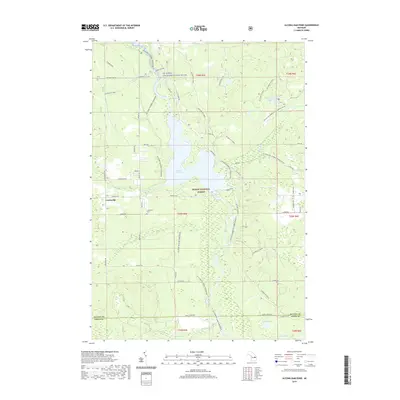
2019 Map of Alcona Dam Pond
USGS Topo · Published 2019About this map
Alcona Dam Pond dominates this portion of the Huron National Forest, where the reservoir backup meets the flowing Au Sable Wild and Scenic River. The settlement of Curtisville sits at the western edge of the quadrangle, serving as a focal point for local history along with the nearby Curtisville Cem. This 2019 survey documents a landscape heavily defined by modern recreational infrastructure and conservation management. Numerous specialized routes, such as the Alcona ATV Trail and the Shore to Shore Horsebike trail, wind through the timbered sections between water bodies like Honawan Lake and Horseshoe Lake. The map also captures the transition between Alcona and Iosco counties, following a grid of forest roads like Bamfield Rd and Curtisville Rd that provide access to the river's many tributaries including Wilbur Cr and Bamfield Creek.
Find a feature on this map
55 named features on this map. Tap any name to fly to it.
Don’t see what you’re looking for? This feature index may not catch every label — zoom into the map to look around manually.
Map Details
Editions of this 2019 Alcona Dam Pond Map
This is the sole edition of this map. No revisions or reprints were ever made.
Other maps of this area

1954 · Tawas City
USGS Topo · 1:250,000

1958 · Tawas City
USGS Topo · 1:250,000

1959 · Tawas City
USGS Topo · 1:62,500

1959 · Glennie
USGS Topo · 1:62,500

1968 · Hale
USGS Topo · 1:24,000

1968 · South Branch
USGS Topo · 1:24,000

1972 · McKinley
USGS Topo · 1:24,000

1972 · Curran
USGS Topo · 1:24,000

1972 · Goodar
USGS Topo · 1:24,000

1972 · Alcona Dam Pond
USGS Topo · 1:24,000