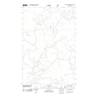
2011 Map of Alder Creek Flats
USGS Topo · Published 2011About this map
Alder Creek Flats occupies the central portion of this 2011 survey, a region defined by its complex drainage network and forest access routes in Benewah County. The landscape is carved by numerous waterways, most notably the Saint Maries River and Alder Creek, which are fed by several smaller tributaries including Happy Creek and Carlin Creek. The settlement of Hollywood appears on the eastern edge of the map, while the high ground at John Point overlooks the junction of several drainage basins. A detailed network of Forest Service roads, such as Nat For Dev Rd 387 and NFD 387 Rd, indicates the ongoing importance of timber management and backcountry access in this Idaho interior during the early 21st century.
Find a feature on this map
22 named features on this map. Tap any name to fly to it.
Don’t see what you’re looking for? This feature index may not catch every label — zoom into the map to look around manually.
Map Details
Editions of this 2011 Alder Creek Flats Map
This is the sole edition of this map. No revisions or reprints were ever made.
Other maps of this area

1955 · Spokane
USGS Topo · 1:250,000

1957 · St. Maries
USGS Topo · 1:62,500

1957 · Emida
USGS Topo · 1:62,500

1957 · Plummer
USGS Topo · 1:62,500

1957 · Tensed
USGS Topo · 1:62,500

1958 · Spokane
USGS Topo · 1:250,000

1975 · Plummer SE
USGS Topo · 1:24,000

1981 · St Maries
USGS Topo · 1:100,000
1981 · St Maries
USGS Topo · 1:24,000
1981 · Benewah Lake
USGS Topo · 1:24,000