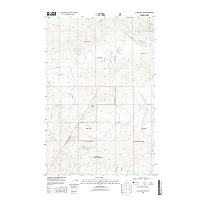
2013 Map of Alder Creek Flats
USGS Topo · Published 2013About this map
Alder Creek Flats serves as a central reference point in this timber-rich portion of northern Idaho, where the drainage systems of the Saint Maries River and its various tributaries define the local geography. Much of the southern and central terrain is dominated by the St Joe National Forest, a landscape marked by significant elevation changes at landmarks like John Point. The map illustrates a network of forest and local access roads, such as Alder Creek Rd and the N Fork Santa Creek Rd, which provide access to more isolated areas and small clusters like Hollywood. The presence of numerous named drainages, including Carlin Cr, Happy Cr, and Cherry Cr, highlights the intricate watershed management and natural topography that have long influenced the region's development and land use patterns.
Find a feature on this map
32 named features on this map. Tap any name to fly to it.
Don’t see what you’re looking for? This feature index may not catch every label — zoom into the map to look around manually.
Map Details
Editions of this 2013 Alder Creek Flats Map
This is the sole edition of this map. No revisions or reprints were ever made.
Other maps of this area

1955 · Spokane
USGS Topo · 1:250,000

1957 · St. Maries
USGS Topo · 1:62,500

1957 · Emida
USGS Topo · 1:62,500

1957 · Plummer
USGS Topo · 1:62,500

1957 · Tensed
USGS Topo · 1:62,500

1958 · Spokane
USGS Topo · 1:250,000

1975 · Plummer SE
USGS Topo · 1:24,000

1981 · St Maries
USGS Topo · 1:100,000
1981 · St Maries
USGS Topo · 1:24,000
1981 · Benewah Lake
USGS Topo · 1:24,000