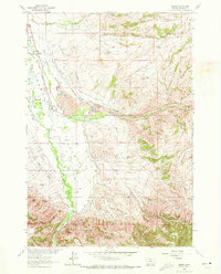
1963 Map of Alder
USGS Topo · Published 1972About this map
Ruby Valley settlement in the early 1960s is defined by a sophisticated network of water management, where the Ruby River is diverted into numerous named channels like Combs Ditch, Phillips Ditch, and the Vigilante Canal. This irrigation infrastructure supports the agricultural land surrounding Laurin and Alder, while the landscape to the east bears the heavy physical marks of Montana's mining heritage. The area between Ruby and Granite Spring is dominated by extensive Dredge Tailings along Alder Gulch, a clear indication of the industrial-scale placer mining that reshaped the valley floor.
Find a feature on this map
45 named features on this map. Tap any name to fly to it.
Don’t see what you’re looking for? This feature index may not catch every label — zoom into the map to look around manually.
Map Details
Editions of this 1963 Alder Map
3 editions found
Other maps of this area

1888 · Three Forks
USGS Topo · 1:250,000

1893 · Dillon
USGS Topo · 1:250,000

1894 · Three Forks
USGS Topo · 1:250,000

1895 · Three Forks
USGS Topo · 1:250,000

1947 · Bozeman
USGS Topo · 1:250,000

1948 · Bozeman
USGS Topo · 1:250,000

1949 · Varney
USGS Topo · 1:62,500

1950 · Virginia City
USGS Topo · 1:62,500

1955 · Bozeman
USGS Topo · 1:250,000

1955 · Dillon
USGS Topo · 1:250,000