
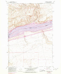
1962 Map of Alderdale
USGS Topo · Published 1963About this map
The Columbia River forms the central spine of this 1962 landscape, where the Oregon and Washington borders meet amidst a complex network of mid-river landforms. Small settlements like Alderdale on the northern bank and McCredie to the west are positioned near the water, while the river itself is dotted with named features such as Thanksgiving Island, Island No 25, and Island No 27. The terrain transitions sharply from the riverbanks to the high plateaus of Alder Ridge and Sand Ridge, cut through by deep drainage features like Dead Canyon and Sixmile Canyon.
Find a feature on this map
26 named features on this map. Tap any name to fly to it.
Don’t see what you’re looking for? This feature index may not catch every label — zoom into the map to look around manually.
Map Details
Editions of this 1962 Alderdale Map
2 editions found
Other maps of this area

1906 · Blalock Island
USGS Topo · 1:125,000

1908 · Blalock Island
USGS Topo · 1:125,000

1916 · Arlington
USGS Topo · 1:125,000

1953 · Pendleton
USGS Topo · 1:250,000

1953 · The Dalles
USGS Topo · 1:250,000

1956 · The Dalles
USGS Topo · 1:250,000

1956 · Pendleton
USGS Topo · 1:250,000

1957 · The Dalles
USGS Topo · 1:250,000
1962 · Phinny Hill
USGS Topo · 1:24,000

1962 · Canoe Ridge
USGS Topo · 1:24,000