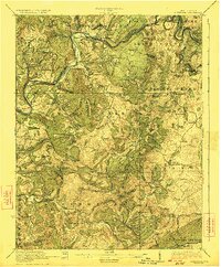
1923 Map of Alderson
USGS Topo · Published 1923About this map
Salt Sulphur Springs and Pence Springs anchor this 1920s topography, reflecting the historical prominence of mineral springs in the region. The Greenbrier River carves a deep path across the northern landscape, accompanied by the Chesapeake and Ohio RR which connects riverfront settlements like Alderson, Lowell, and Talcott. The map reveals a dense network of early 20th-century rural infrastructure, including local landmarks like Hokes Mill and the Sinks Grove P O.
Find a feature on this map
107 named features on this map. Tap any name to fly to it.
Don’t see what you’re looking for? This feature index may not catch every label — zoom into the map to look around manually.
Map Details
Editions of this 1923 Alderson Map
3 editions found
Other maps of this area

1887 · Hinton
USGS Topo · 1:125,000

1887 · Lewisburg
USGS Topo · 1:125,000

1890 · Dublin
USGS Topo · 1:125,000

1890 · Christiansburg
USGS Topo · 1:125,000

1891 · Lewisburg
USGS Topo · 1:125,000

1891 · Dublin
USGS Topo · 1:125,000

1892 · Hinton
USGS Topo · 1:125,000

1912 · Meadow Creek
USGS Topo · 1:48,000

1912 · Big Bend
USGS Topo · 1:62,500

1913 · Peterstown
USGS Topo · 1:48,000