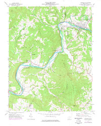
1971 Map of Alderson
USGS Topo · Published 1977About this map
The Greenbrier River dominates this West Virginia landscape, winding through a series of steep bends where the borders of Greenbrier, Summers, and Monroe counties converge. The town of Alderson serves as a primary hub, notable for the prominent Federal Reformatory for Women complex along the riverbank and the nearby Mountain State High Sch. Downstream, the river corridor supports the Hinton-Alderson Airfield and the community of Pence Springs, illustrating the concentration of infrastructure and settlement within the narrow valley flats.
Find a feature on this map
51 named features on this map. Tap any name to fly to it.
Don’t see what you’re looking for? This feature index may not catch every label — zoom into the map to look around manually.
Map Details
Editions of this 1971 Alderson Map
2 editions found
Other maps of this area

1887 · Hinton
USGS Topo · 1:125,000

1892 · Hinton
USGS Topo · 1:125,000

1912 · Meadow Creek
USGS Topo · 1:48,000

1912 · Big Bend
USGS Topo · 1:62,500

1914 · Big Bend
USGS Topo · 1:62,500

1915 · Meadow Creek
USGS Topo · 1:62,500

1921 · Alderson
USGS Topo · 1:48,000

1921 · Clintonville
USGS Topo · 1:48,000

1923 · Clintonville
USGS Topo · 1:62,500
1923 · Alderson
USGS Topo · 1:62,500