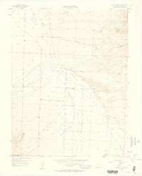
1957 Map of Aldrich Gulch
USGS Topo · Published 1958About this map
Grape Creek and its many tributaries, including North Colony Creek and South Colony Creek, define the drainage patterns across this part of Custer County. The map captures the rugged eastern slope of the Sangre de Cristo range during the late 1950s, showing a landscape transition from the high Rosita Hills down into the wide Mountain Valley. The placement of Silver Cliff Cemetery and Hope Cemetery indicates the locations of early area burials, while the inclusion of the San Isabel National Forest boundary reflects the region's managed public lands. Local transport relies on a network of named routes such as Schoolfield Road and Stanton Road, which provided access for the area's ranchers and early industrial operations like the Strip Mine and Gravel Pit.
Find a feature on this map
26 named features on this map. Tap any name to fly to it.
Don’t see what you’re looking for? This feature index may not catch every label — zoom into the map to look around manually.
Map Details
Editions of this 1957 Aldrich Gulch Map
5 editions found

Other maps of this area

1889 · Canon City
USGS Topo · 1:125,000

1889 · Huerfano Park
USGS Topo · 1:125,000

1892 · Huerfano Park
USGS Topo · 1:125,000

1892 · Canon City
USGS Topo · 1:125,000

1954 · Mount Tyndall
USGS Topo · 1:24,000

1954 · Rosita
USGS Topo · 1:24,000

1954 · Trinidad
USGS Topo · 1:250,000

1954 · Pueblo
USGS Topo · 1:250,000

1955 · Westcliffe
USGS Topo · 1:24,000

1955 · Trinidad
USGS Topo · 1:250,000