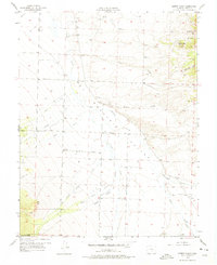
1957 Map of Aldrich Gulch
USGS Topo · Published 1975About this map
Wet Mountain Valley dominates this 1950s landscape, serving as a pastoral basin framed by the rising peaks of the San Isabel National Forest. This era of Custer County history is characterized by a network of drainage systems including Grape Creek, Antelope Creek, and the various branches of Colony Creek, which descend from the high ground into the valley floor. The map highlights the intersection of local transportation and rural life, featuring prominent thoroughfares such as Schoolfield Road and Marble Road.
Find a feature on this map
26 named features on this map. Tap any name to fly to it.
Don’t see what you’re looking for? This feature index may not catch every label — zoom into the map to look around manually.
Map Details
Editions of this 1957 Aldrich Gulch Map
5 editions found

Other maps of this area

1889 · Canon City
USGS Topo · 1:125,000

1889 · Huerfano Park
USGS Topo · 1:125,000

1892 · Huerfano Park
USGS Topo · 1:125,000

1892 · Canon City
USGS Topo · 1:125,000

1954 · Mount Tyndall
USGS Topo · 1:24,000

1954 · Rosita
USGS Topo · 1:24,000

1954 · Trinidad
USGS Topo · 1:250,000

1954 · Pueblo
USGS Topo · 1:250,000

1955 · Westcliffe
USGS Topo · 1:24,000

1955 · Trinidad
USGS Topo · 1:250,000