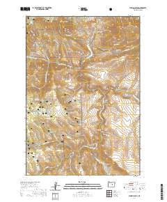
2020 Map of Aldrich Gulch
USGS Topo · Published 2020About this map
South Fork John Day Wild and Scenic River carves a deep path through the eastern portion of the Ochoco National Forest, defining the rugged topography of this Grant County landscape. The area is marked by a complex system of water management and high-country landmarks, including numerous small reservoirs such as Lost Indian Reservoir, Wigwam Reservoir, and Ringsmeyer Reservoir. High elevations are dominated by prominent peaks like Battle Creek Mtn and Jackass Mtn, while the drainage network of Black Canyon Cr and Murderers Cr illustrates the erosive power that shaped the many named gulches here. This modern survey reflects a region primarily managed for natural resources and conservation, where historic place names like Aldrich Gulch, Doghouse Gulch, and Chickenhouse Gulch provide a window into the former livestock and pioneering activities of the Oregon backcountry.
Find a feature on this map
53 named features on this map. Tap any name to fly to it.
Don’t see what you’re looking for? This feature index may not catch every label — zoom into the map to look around manually.
Map Details
Editions of this 2020 Aldrich Gulch Map
This is the sole edition of this map. No revisions or reprints were ever made.
Other maps of this area

1932 · Dayville
USGS Topo · 1:125,000

1936 · Dayville
USGS Topo · 1:125,000

1940 · Aldrich Mtn.
USGS Topo · 1:62,500

1943 · Aldrich Mtn.
USGS Topo · 1:62,500

1955 · Canyon City
USGS Topo · 1:250,000

1959 · Canyon City
USGS Topo · 1:250,000

1961 · Izee
USGS Topo · 1:62,500

1972 · Wolf Mountain
USGS Topo · 1:24,000

1972 · Day Basin
USGS Topo · 1:24,000
1972 · Aldrich Mountain North
USGS Topo · 1:24,000