
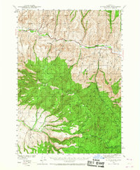
1940 Map of Aldrich Mtn.
USGS Topo · Published 1960About this map
The John Day River carves through this Grant County landscape, serving as a primary corridor for ranching and travel during the late 1930s. Surveyed by R. R. Monbeck and E. S. Rickard, the map reveals a rugged backcountry where isolation necessitated established waypoints like Stewarts Crossing and Moores Crossing. The settlement pattern is defined by family-named holdings, including the Black Ranch, Gay Ranch, and Glascock Ranch, many of which relied on the numerous springs such as Lick Spr and Roaring Spr for survival in the arid terrain.
Find a feature on this map
95 named features on this map. Tap any name to fly to it.
Don’t see what you’re looking for? This feature index may not catch every label — zoom into the map to look around manually.
Map Details
Editions of this 1940 Aldrich Mtn. Map
2 editions found
Other maps of this area

1932 · Dayville
USGS Topo · 1:125,000

1936 · Dayville
USGS Topo · 1:125,000

1940 · Mount Vernon
USGS Topo · 1:62,500

1943 · Aldrich Mtn.
USGS Topo · 1:62,500

1943 · Mount Vernon
USGS Topo · 1:62,500

1949 · Long Creek
USGS Topo · 1:62,500

1951 · Long Creek
USGS Topo · 1:62,500

1951 · Courtrock
USGS Topo · 1:62,500

1953 · Picture
USGS Topo · 1:62,500

1955 · Canyon City
USGS Topo · 1:250,000