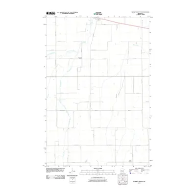
2010 Map of Aldrich South
USGS Topo · Published 2010About this map
Aldrich sits at the northern edge of this agricultural landscape, where the local road network follows a rigid section-line grid typical of central Minnesota. The terrain is defined by the winding course of the Partridge River and its tributaries, including the Little Partridge River and Egly Creek, which break the geometric precision of the surrounding farm lots. This area, south of the Wing River, serves as a transition between the more developed settlement at the top of the sheet and the open rural expanses to the south. Two primary burial grounds, Balsamlund Cemetery and the Moran-Germania Cemetery near the banks of Moran Creek, provide important touchpoints for family historians and genealogists tracing the early settlers of Wadena County. The preservation of local road names like Todd Line Rd and Thorn Apple Rd reflects the enduring rural character of the region in the early 21st century.
Find a feature on this map
35 named features on this map. Tap any name to fly to it.
Don’t see what you’re looking for? This feature index may not catch every label — zoom into the map to look around manually.
Map Details
Editions of this 2010 Aldrich South Map
This is the sole edition of this map. No revisions or reprints were ever made.
Other maps of this area

1953 · Brainerd
USGS Topo · 1:250,000

1957 · Brainerd
USGS Topo · 1:250,000

1958 · Brainerd
USGS Topo · 1:250,000

1965 · Brainerd
USGS Topo · 1:250,000

1966 · Staples NE
USGS Topo · 1:24,000
1966 · Browerville NE
USGS Topo · 1:24,000

1966 · Staples
USGS Topo · 1:24,000

1966 · Aldrich North
USGS Topo · 1:24,000
1966 · Clarissa
USGS Topo · 1:24,000

1966 · Aldrich South
USGS Topo · 1:24,000