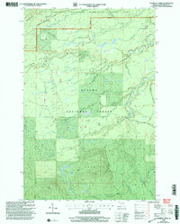
1999 Map of Aldridge Creek
USGS Topo · Published 2004About this map
Porcupine Mountains State Park and the Ottawa National Forest dominate this Upper Peninsula landscape, showcasing a complex network of waterways that flow north toward Lake Superior. The terrain is defined by the Porcupine Mountains and the Bergland highlands, where drainage systems like the Big Iron River and Little Iron River carve through the timberland. Historically, the area reflects the region's industrial past, evidenced by the White Pine Extension Mine located near the park boundary. Recreational development is prominent through the inclusion of the North Country National Scenic Trail, which traverses the northern ridges. Notable water features including Deer Creek Falls and Rapid River Falls highlight the significant elevation drops within the Bergland District during this turn-of-the-millennium survey.
Find a feature on this map
25 named features on this map. Tap any name to fly to it.
Don’t see what you’re looking for? This feature index may not catch every label — zoom into the map to look around manually.
Map Details
Editions of this 1999 Aldridge Creek Map
This is the sole edition of this map. No revisions or reprints were ever made.
Other maps of this area

1949 · White Pine
USGS Topo · 1:24,000

1949 · Bergland NE
USGS Topo · 1:24,000

1956 · Carp River
USGS Topo · 1:62,500

1956 · Bergland NE
USGS Topo · 1:24,000

1956 · Bergland
USGS Topo · 1:62,500

1956 · Thomaston
USGS Topo · 1:62,500

1956 · White Pine
USGS Topo · 1:24,000

1956 · White Pine
USGS Topo · 1:62,500

1958 · Iron River
USGS Topo · 1:250,000

1960 · Iron River
USGS Topo · 1:250,000