
1956 Map of White Pine
USGS Topo · Published 1958About this map
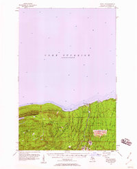
Industrial copper mining and high-country wilderness meet along the shoreline of Lake Superior in this mid-century survey. The massive infrastructure of the White Pine Mine dominates the southeastern quadrant, featuring a prominent Smoke Stack, a Tailings Pond, and an above ground pipeline stretching toward the Iron River. This industrial footprint contrasts sharply with the western peaks of the Porcupine Mountains State Park, where the land rises to Government Peak and Cloud Peak. Historical mining attempts are visible as the Cuyahoga Mine and Carp Lake Mine near the high-elevation Lake of the Clouds. The settlement of Silver City sits at the mouth of the Big Iron River on Union Bay, serving as a coastal gateway to the timber and mineral resources of the Ottawa National Forest.
Find a feature on this map
55 named features on this map. Tap any name to fly to it.
Don’t see what you’re looking for? This feature index may not catch every label — zoom into the map to look around manually.
Map Details
Editions of this 1956 White Pine Map
3 editions found
Other maps of this area

1949 · Matchwood NW
USGS Topo · 1:24,000

1949 · White Pine
USGS Topo · 1:24,000

1949 · Bergland NE
USGS Topo · 1:24,000

1955 · Ontonagon
USGS Topo · 1:62,500

1956 · Carp River
USGS Topo · 1:62,500

1956 · Bergland NE
USGS Topo · 1:24,000

1956 · Bergland
USGS Topo · 1:62,500

1956 · Thomaston
USGS Topo · 1:62,500

1956 · White Pine
USGS Topo · 1:24,000

1956 · Matchwood NW
USGS Topo · 1:24,000