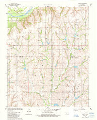
1985 Map of Aledo
USGS Topo · Published 1985About this map
The Canadian River flows through the northwest corner of this region, marking a distinct geographical boundary where the rolling hills of western Oklahoma meet the water. During the mid-1980s, this area on the border of Dewey Co Custer Co was defined by its agricultural and energy production. Small community hubs like Aledo and Burmah anchor the landscape, while the presence of the Prairie Bell Ch and Elm Cem suggests the deep-rooted social and family histories of these rural townships. The map reveals an intensive network of natural resource extraction, indicated by numerous Gas Wells, Oil Wells, and Drill Holes scattered across the survey blocks. These industrial markers, alongside the meandering East Barnitz Creek, create a detailed picture of a landscape where traditional farming and modern energy interests coexist.
Find a feature on this map
18 named features on this map. Tap any name to fly to it.
Don’t see what you’re looking for? This feature index may not catch every label — zoom into the map to look around manually.
Map Details
Editions of this 1985 Aledo Map
This is the sole edition of this map. No revisions or reprints were ever made.
Other maps of this area

1955 · Clinton
USGS Topo · 1:250,000

1957 · Clinton
USGS Topo · 1:250,000

1957 · Butler
USGS Topo · 1:62,500

1957 · Clinton
USGS Topo · 1:62,500

1962 · Putnam
USGS Topo · 1:62,500

1962 · Aledo
USGS Topo · 1:62,500

1976 · Butler NW
USGS Topo · 1:24,000

1976 · Butler NE
USGS Topo · 1:24,000

1976 · Clinton NW
USGS Topo · 1:24,000
1983 · Custer City
USGS Topo · 1:24,000