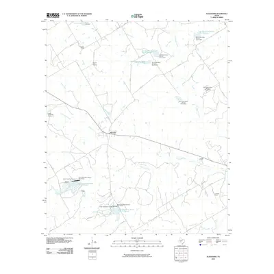
2010 Map of Alexander
USGS Topo · Published 2010About this map
Alexander sits at the center of this rural Erath County landscape, serving as a focal point for the network of farm-to-market roads and county routes that crisscross the terrain. The map reveals a land heavily managed for water conservation, defined by numerous reservoirs such as Soil Conservation Service Site 21 Reservoir and Soil Conservation Service Site 13 Reservoir. These projects, often tied to the drainage basins of the North Bosque River and Green Creek, illustrate the intersection of agricultural needs and modern hydrological management. Local history is anchored by several family-named burial grounds, including the Bowman Ridge Cemetery, Hancock Cemetery, and Caudle Cemetery, which reflect the generations of families who settled these ridges. To the northeast, the Clairette Cemetery marks the periphery of the quadrangle, while landmarks like Bowman Ridge and the private J F Ranch Airport further distinguish the local geography.
Find a feature on this map
59 named features on this map. Tap any name to fly to it.
Don’t see what you’re looking for? This feature index may not catch every label — zoom into the map to look around manually.
Map Details
Editions of this 2010 Alexander Map
This is the sole edition of this map. No revisions or reprints were ever made.
Other maps of this area

1888 · Hamilton
USGS Topo · 1:125,000

1890 · Stephenville
USGS Topo · 1:125,000

1894 · Hamilton
USGS Topo · 1:125,000

1920 · Stephenville
USGS Topo · 1:125,000

1954 · Brownwood
USGS Topo · 1:250,000

1954 · Abilene
USGS Topo · 1:250,000

1956 · Gustine
USGS Topo · 1:62,500

1956 · Hico
USGS Topo · 1:62,500
1956 · Edna Hill
USGS Topo · 1:24,000
1956 · Carlton
USGS Topo · 1:24,000