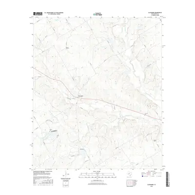
2016 Map of Alexander
USGS Topo · Published 2016About this map
Alexander serves as the central settlement on this Erath County landscape, situated where FM 914 intersects the local road network. The terrain is defined by a dense web of waterways, most notably the N Bosque River and its various tributaries such as Alarm Cr, Green Cr, and Live Oak Cr. The distribution of rural cemeteries, including Bowman Ridge Cem to the north and Hancock Cem and Gaudle Cem to the southwest, suggests long-established family landholdings and small community centers. To the southeast, Clairette Cem marks another point of local historical interest. Modern land use is visible through the presence of the J F Ranch Airport and water management features like Farrow Lake, reflecting the continued agricultural and private aviation character of this central Texas region.
Find a feature on this map
52 named features on this map. Tap any name to fly to it.
Don’t see what you’re looking for? This feature index may not catch every label — zoom into the map to look around manually.
Map Details
Editions of this 2016 Alexander Map
This is the sole edition of this map. No revisions or reprints were ever made.
Other maps of this area

1888 · Hamilton
USGS Topo · 1:125,000

1890 · Stephenville
USGS Topo · 1:125,000

1894 · Hamilton
USGS Topo · 1:125,000

1920 · Stephenville
USGS Topo · 1:125,000

1954 · Brownwood
USGS Topo · 1:250,000

1954 · Abilene
USGS Topo · 1:250,000

1956 · Gustine
USGS Topo · 1:62,500

1956 · Hico
USGS Topo · 1:62,500
1956 · Edna Hill
USGS Topo · 1:24,000
1956 · Carlton
USGS Topo · 1:24,000