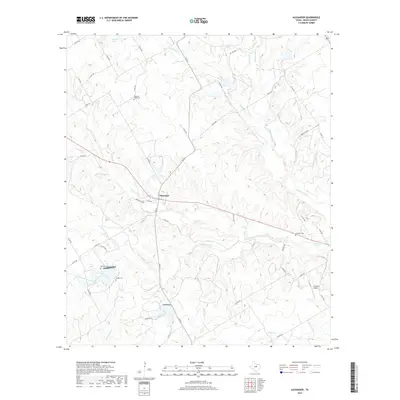
2019 Map of Alexander
USGS Topo · Published 2019About this map
The community of Alexander serves as the focal point of this central Texas landscape, where the agricultural and ranching traditions of Erath County are evident in the dense network of rural routes like FM 914 and Co RD 282. The terrain is defined by the drainage basins of the N Bosque River and its numerous tributaries, including Green Cr and Little Green Cr, which carve a rolling path through the local topography. For genealogists, the map preserves the locations of several smaller burial grounds that mark the heritage of local families and settlements, such as Bowman Ridge Cem to the north and Clairette Cem to the east. Modern land use is further highlighted by private infrastructure like the J F Ranch Airport, reflecting the continued importance of large-scale ranching operations in this portion of the Cross Timbers region.
Find a feature on this map
54 named features on this map. Tap any name to fly to it.
Don’t see what you’re looking for? This feature index may not catch every label — zoom into the map to look around manually.
Map Details
Editions of this 2019 Alexander Map
This is the sole edition of this map. No revisions or reprints were ever made.
Other maps of this area

1888 · Hamilton
USGS Topo · 1:125,000

1890 · Stephenville
USGS Topo · 1:125,000

1894 · Hamilton
USGS Topo · 1:125,000

1920 · Stephenville
USGS Topo · 1:125,000

1954 · Brownwood
USGS Topo · 1:250,000

1954 · Abilene
USGS Topo · 1:250,000

1956 · Gustine
USGS Topo · 1:62,500

1956 · Hico
USGS Topo · 1:62,500
1956 · Edna Hill
USGS Topo · 1:24,000
1956 · Carlton
USGS Topo · 1:24,000