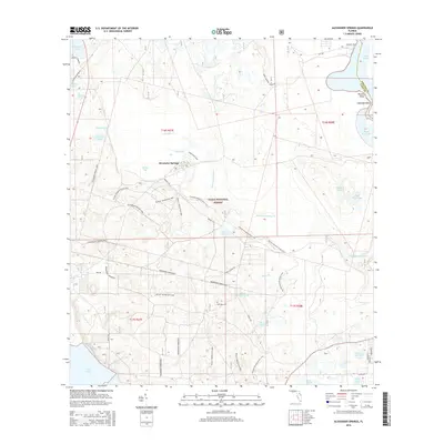
2015 Map of Alexander Springs
USGS Topo · Published 2015About this map
Alexander Springs serves as the focal point of this modern survey, which details a landscape deeply integrated into the Ocala National Forest. The geography is defined by a dense network of hydrologic features, from the expansive Lake Dexter on the eastern boundary to Lake Dorr in the southwest, connected by waterways like Alexander Springs Cr. For the local historian, the presence of Shockley Cem and the naming of Bowers Bluff and Idlewild Point offer specific points of human activity and lineage. The map reflects a modern recreational and conservationist era, evidenced by the extensive trail systems including the Florida National Scenic Trail and specialized paths such as the Paisley Woods Mtn Bike trail and Flatwoods Riding Loop. These trails often follow older corridors, such as Railroad Grade Rd, illustrating how historic transit routes have been repurposed for contemporary access.
Find a feature on this map
46 named features on this map. Tap any name to fly to it.
Don’t see what you’re looking for? This feature index may not catch every label — zoom into the map to look around manually.
Map Details
Editions of this 2015 Alexander Springs Map
This is the sole edition of this map. No revisions or reprints were ever made.
Other maps of this area

1954 · Daytona Beach
USGS Topo · 1:250,000

1955 · Orlando
USGS Topo · 1:250,000

1957 · Orlando
USGS Topo · 1:250,000

1958 · Orlando
USGS Topo · 1:250,000

1958 · Daytona Beach
USGS Topo · 1:250,000

1962 · Orlando
USGS Topo · 1:250,000

1962 · Pine Lakes
USGS Topo · 1:24,000

1962 · Lake Woodruff
USGS Topo · 1:24,000

1964 · Daytona Beach
USGS Topo · 1:250,000

1965 · Umatilla
USGS Topo · 1:24,000