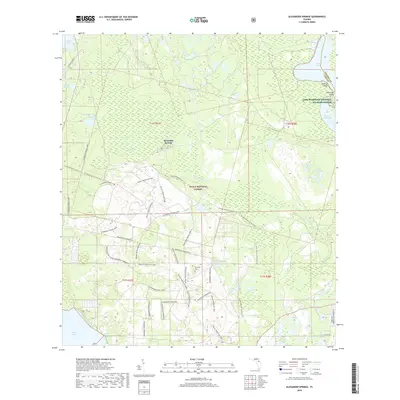
2018 Map of Alexander Springs
USGS Topo · Published 2018About this map
Ocala National Forest dominates this Central Florida landscape, defined by a complex network of springs, creeks, and standing water. The namesake Alexander Springs serves as a primary hydrological hub, feeding into Alexander Springs Cr as it flows toward the Lake and Volusia County line. To the east, the Lake Woodruff National Wildlife Refuge borders the wide expanse of Lake Dexter, where shoreline features like Bowers Bluff and Idlewild Point mark the transition from cypress swamp to open water.
Find a feature on this map
44 named features on this map. Tap any name to fly to it.
Don’t see what you’re looking for? This feature index may not catch every label — zoom into the map to look around manually.
Map Details
Editions of this 2018 Alexander Springs Map
This is the sole edition of this map. No revisions or reprints were ever made.
Other maps of this area

1954 · Daytona Beach
USGS Topo · 1:250,000

1955 · Orlando
USGS Topo · 1:250,000

1957 · Orlando
USGS Topo · 1:250,000

1958 · Orlando
USGS Topo · 1:250,000

1958 · Daytona Beach
USGS Topo · 1:250,000

1962 · Orlando
USGS Topo · 1:250,000

1962 · Pine Lakes
USGS Topo · 1:24,000

1962 · Lake Woodruff
USGS Topo · 1:24,000

1964 · Daytona Beach
USGS Topo · 1:250,000

1965 · Umatilla
USGS Topo · 1:24,000