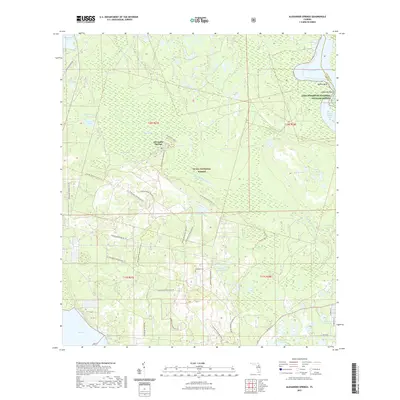
2021 Map of Alexander Springs
USGS Topo · Published 2021About this map
Ocala National Forest and Lake Woodruff National Wildlife Refuge define this central Florida landscape, where the waters of Lake Dexter and Lake Dorr frame a complex network of wetlands and creeks. The hydrology is dominated by Alexander Springs Cr and the namesake Alexander Springs settlement, while the presence of Tracy Canal and Railroad Grade Rd indicates how historical transportation and drainage projects have shaped the terrain. Near the center of the sheet, the Shockley Cem serves as a localized genealogical marker amidst the forested tracts. An extensive modern trail system, including the Florida National Scenic Trl and various loops like the Flatwoods Riding Loop Trl, demonstrates the transition of this area from a working timber and rail landscape into a major recreational corridor.
Find a feature on this map
44 named features on this map. Tap any name to fly to it.
Don’t see what you’re looking for? This feature index may not catch every label — zoom into the map to look around manually.
Map Details
Editions of this 2021 Alexander Springs Map
This is the sole edition of this map. No revisions or reprints were ever made.
Other maps of this area

1954 · Daytona Beach
USGS Topo · 1:250,000

1955 · Orlando
USGS Topo · 1:250,000

1957 · Orlando
USGS Topo · 1:250,000

1958 · Orlando
USGS Topo · 1:250,000

1958 · Daytona Beach
USGS Topo · 1:250,000

1962 · Orlando
USGS Topo · 1:250,000

1962 · Pine Lakes
USGS Topo · 1:24,000

1962 · Lake Woodruff
USGS Topo · 1:24,000

1964 · Daytona Beach
USGS Topo · 1:250,000

1965 · Umatilla
USGS Topo · 1:24,000