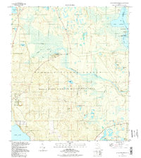
1994 Map of Alexander Springs
USGS Topo · Published 1998About this map
Alexander Springs Creek winds through a vast expanse of protected Florida wilderness, forming a vital hydrologic link between the Ocala National Forest and the St Johns River system. The map documents a landscape defined by subtropical hydrology, where named water bodies like Lake Dexter and Lake Dorr are interspersed with specialized environments such as Billies Bay and Stagger Mud Lake. While much of the terrain is dedicated to conservation within the Ocala State Wildlife Management Area, evidence of human geography appears at Hinson and the secluded Stockley Cem. The reliance on 4WD tracks and the presence of a Lookout Tower underscore the remote character of this region during the late 20th century, before major modern shifts in water management or forest infrastructure.
Find a feature on this map
35 named features on this map. Tap any name to fly to it.
Don’t see what you’re looking for? This feature index may not catch every label — zoom into the map to look around manually.
Map Details
Editions of this 1994 Alexander Springs Map
This is the sole edition of this map. No revisions or reprints were ever made.
Other maps of this area

1954 · Daytona Beach
USGS Topo · 1:250,000

1955 · Orlando
USGS Topo · 1:250,000

1957 · Orlando
USGS Topo · 1:250,000

1958 · Orlando
USGS Topo · 1:250,000

1958 · Daytona Beach
USGS Topo · 1:250,000

1962 · Orlando
USGS Topo · 1:250,000

1962 · Pine Lakes
USGS Topo · 1:24,000

1962 · Lake Woodruff
USGS Topo · 1:24,000

1964 · Daytona Beach
USGS Topo · 1:250,000

1965 · Umatilla
USGS Topo · 1:24,000