
1929 Map of Alexandria
USGS Topo · Published 1929About this map
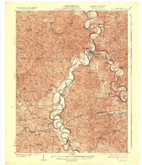
The Alexandria vicinity and the winding valleys of Campbell and Kenton Counties are captured here just before the 1930s. The landscape is defined by the sharp meanders of the Licking River and the Ohio River, with the Louisville & Nashville RR following the Licking's western bank through Morning View and De Mossville. This era reveals a high density of rural institutions, particularly parochial and public schools like Sts Peter and Paul Sch and the Ten Mile Sch, serving scattered farming communities. The presence of Dam 35 on the Ohio River and various stations like Alexander Sta highlight the region's reliance on river and rail transport for both passengers and commerce. Smaller settlements such as Grants Lick and Gubsers Mill anchor the interior, connected by a network of creeks and ridge-top roads.
Find a feature on this map
84 named features on this map. Tap any name to fly to it.
Don’t see what you’re looking for? This feature index may not catch every label — zoom into the map to look around manually.
Map Details
Editions of this 1929 Alexandria Map
This is the sole edition of this map. No revisions or reprints were ever made.
Other maps of this area

1898 · East Cincinnati
USGS Topo · 1:62,500

1914 · East Cincinnati
USGS Topo · 1:62,500

1914 · West Cincinnati
USGS Topo · 1:62,500

1914 · Batavia
USGS Topo · 1:48,000

1916 · Batavia
USGS Topo · 1:62,500

1930 · Falmouth
USGS Topo · 1:48,000

1931 · Felicity
USGS Topo · 1:62,500

1936 · Alexandria
USGS Topo · 1:62,500
1936 · Falmouth
USGS Topo · 1:62,500
1950 · Williamstown
USGS Topo · 1:24,000