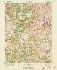
1961 Map of Alexandria
USGS Topo · Published 1973About this map
The Licking River carves a dramatic oxbow at Grants Bend, defining the border between Kenton and Campbell Counties. This mid-century landscape is dominated by the Louisville and Nashville RR, which follows the river's path, connecting small riverfront settlements like Visalia and Grant. To the east, the county seat of Alexandria serves as a local hub, surrounded by upland ridges like Stevens Ridge and Poplar Ridge. The map reveals a community structured around its rural institutions, including Ryland Heights Sch and churches such as Pleasant Ridge Ch. Near the northern boundary, more developed areas like Taylor Mill and Latonia Lakes signal the post-war expansion toward the urban centers of the Ohio River valley, while interior regions remain characterized by winding hollows and narrow ridge-top roads like Decoursey Road.
Find a feature on this map
39 named features on this map. Tap any name to fly to it.
Don’t see what you’re looking for? This feature index may not catch every label — zoom into the map to look around manually.
Map Details
Editions of this 1961 Alexandria Map
2 editions found
Other maps of this area

1898 · East Cincinnati
USGS Topo · 1:62,500

1914 · East Cincinnati
USGS Topo · 1:62,500

1914 · West Cincinnati
USGS Topo · 1:62,500

1929 · Alexandria
USGS Topo · 1:48,000

1936 · Alexandria
USGS Topo · 1:62,500

1950 · Independence
USGS Topo · 1:24,000

1950 · Walton
USGS Topo · 1:24,000

1950 · Covington
USGS Topo · 1:24,000

1952 · Newport
USGS Topo · 1:24,000

1953 · Withamsville
USGS Topo · 1:24,000