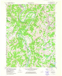
1981 Map of Alexandria
USGS Topo · Published 1982About this map
The Licking River carves a dramatic oxbow at Grants Bend, defining the border between Kenton and Campbell counties in this early 1980s topographical record. The landscape is a network of ridges and hollows, where rural communities like Visalia and Claryville are connected by winding routes such as Persimmon Grove Road and De Coursey Road. The Louisville and Nashville railroad tracks parallel the river's course, serving a region that balances small-town centers like Alexandria with growing residential pockets like Ryland Heights. Local history is preserved through the mapping of country parishes and schools, including St Marys Ch and the McCormick Voc Sch. At the southern edge, the development of A J Jolly County Park and Campbell County Lake highlights the transition toward recreational land use in the late 20th century.
Find a feature on this map
58 named features on this map. Tap any name to fly to it.
Don’t see what you’re looking for? This feature index may not catch every label — zoom into the map to look around manually.
Map Details
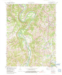
Editions of this 1981 Alexandria Map
2 editions found
Other maps of this area

1898 · East Cincinnati
USGS Topo · 1:62,500

1914 · East Cincinnati
USGS Topo · 1:62,500

1914 · West Cincinnati
USGS Topo · 1:62,500

1929 · Alexandria
USGS Topo · 1:48,000

1936 · Alexandria
USGS Topo · 1:62,500

1950 · Independence
USGS Topo · 1:24,000

1950 · Walton
USGS Topo · 1:24,000

1950 · Covington
USGS Topo · 1:24,000

1952 · Newport
USGS Topo · 1:24,000

1953 · Withamsville
USGS Topo · 1:24,000