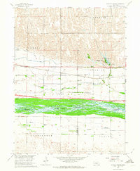
1962 Map of Alfalfa Center
USGS Topo · Published 1964About this map
The Platte River valley in Buffalo County is captured here during a period of significant infrastructure expansion, most notably during the construction of Interstate 80. This major highway corridor is shown cutting through the landscape just south of the Union Pacific tracks, reflecting the shift in mid-century transportation as the interstate began to parallel the historic rail route. The map illustrates a complex water management system, featuring the Kearney Canal and several sloughs, including Whisky Slough, which delineate the low-lying areas of Long Island. Local community life is anchored by small settlements and rural landmarks like the Alfalfa Center and School No 114. Near the northern bluffs, the Dove Hill Cem and Dove Hill overlook the river valley, while the Cottonmill Lake State Recreation Area provides a established public space centered on the waters of Cottonmill Lake.
Find a feature on this map
26 named features on this map. Tap any name to fly to it.
Don’t see what you’re looking for? This feature index may not catch every label — zoom into the map to look around manually.
Map Details
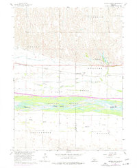
Editions of this 1962 Alfalfa Center Map
2 editions found
Other maps of this area

1894 · Kearney
USGS Topo · 1:62,500

1896 · Kearney
USGS Topo · 1:125,000

1955 · Grand Island
USGS Topo · 1:250,000

1957 · Grand Island
USGS Topo · 1:250,000

1958 · Grand Island
USGS Topo · 1:250,000

1961 · Amherst
USGS Topo · 1:24,000

1962 · Riverdale
USGS Topo · 1:24,000

1962 · Elm Creek East
USGS Topo · 1:24,000
1962 · Pleasanton SE
USGS Topo · 1:24,000
1962 · Kearney
USGS Topo · 1:24,000
Featured Places
- Kearney, NE
- Sheens Trailer Court, NE
- Alfalfa Center, NE
- Cottonmill Mobile Home Court, NE
- Buffalo County, NE