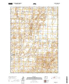
2020 Map of Alfalfa
USGS Topo · Published 2020About this map
The settlement of Alfalfa sits amidst a complex network of irrigation and ancient watercourses in Deschutes County. The landscape is defined by the Central Oregon Canal, which brings essential water to the high desert, and the bed of the Dry River, a prehistoric drainage that remains a prominent geographic feature. Transportation in this era is a mix of utilitarian agriculture routes and recreational access, with Alfalfa Market Rd serving as a primary artery while Cougar Trl skirts the western edge of the quadrangle. Aviation history is represented by Juniper Air Park, located near the southern boundary. Local land use is further evidenced by family-named roads such as Abernathy Rd and Johnson Ranch Rd, which reveal the long-standing ranching and homesteading heritage of the area south of Reynolds Pond.
Find a feature on this map
26 named features on this map. Tap any name to fly to it.
Don’t see what you’re looking for? This feature index may not catch every label — zoom into the map to look around manually.
Map Details
Editions of this 2020 Alfalfa Map
This is the sole edition of this map. No revisions or reprints were ever made.
Other maps of this area

1926 · Bend
USGS Topo · 1:125,000

1929 · Bend
USGS Topo · 1:125,000

1931 · Newberry Crater
USGS Topo · 1:125,000

1935 · Newberry Crater
USGS Topo · 1:125,000

1955 · Crescent
USGS Topo · 1:250,000

1955 · Bend
USGS Topo · 1:250,000

1957 · Crescent
USGS Topo · 1:250,000

1957 · Bend
USGS Topo · 1:250,000

1958 · Crescent
USGS Topo · 1:250,000

1958 · Bend
USGS Topo · 1:250,000