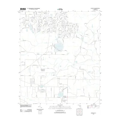
2012 Map of Alford SE
USGS Topo · Published 2012About this map
Camps Head Cem and Pippen Cem anchor the social geography of this rural Jackson County landscape, representing decades of local family history in northern Florida. The terrain is defined by an intricate network of waterways and basins, including the headwaters of Foxworth Mill Cr and the winding course of Econfina Cr. Residential development is concentrated in the northern portion of the map, where a dense grid of streets like Lisbon Ave and Nortek Blvd contrasts with the open woodlands and wetlands to the south.
Find a feature on this map
211 named features on this map. Tap any name to fly to it.
Don’t see what you’re looking for? This feature index may not catch every label — zoom into the map to look around manually.
Map Details
Editions of this 2012 Alford SE Map
This is the sole edition of this map. No revisions or reprints were ever made.
Other maps of this area

1944 · Clarksville
USGS Topo · 1:31,680

1945 · Juniper Creek
USGS Topo · 1:31,680

1945 · Clarksville
USGS Topo · 1:31,680

1945 · Fountain
USGS Topo · 1:31,680

1952 · Oakdale
USGS Topo · 1:24,000

1952 · Kynesville
USGS Topo · 1:24,000

1952 · Alford SE
USGS Topo · 1:24,000

1952 · Altha West
USGS Topo · 1:24,000
1952 · Compass Lake
USGS Topo · 1:24,000
1952 · Alford
USGS Topo · 1:24,000