
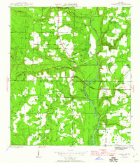
1945 Map of Clarksville
USGS Topo · Published 1945About this map
The Chipola River dominates the eastern half of this landscape, its winding course surrounded by a dense network of swampy tributaries like Wildcat Creek and Fourmile Creek. Situated in Calhoun County at the end of World War II, the settlement of Clarksville serves as a central hub where local roads converge along the east-west Base Line. The map reveals a rural economy rooted in the land, evidenced by Browns Mill Pond and numerous "head" features like Suggs Head and Hewett Head, which denote the spring-fed sources of local branches. Community life is anchored by a significant number of rural institutions, including Travelers Rest Ch and Poplar Head Ch, alongside education sites like Carr Sch. Family legacy is preserved in the landscape through the Barfield Cem and named intersections such as Rollins Corner and Fisher Corner, providing a detailed look at mid-century Florida panhandle settlement patterns.
Find a feature on this map
36 named features on this map. Tap any name to fly to it.
Don’t see what you’re looking for? This feature index may not catch every label — zoom into the map to look around manually.
Map Details
Editions of this 1945 Clarksville Map
2 editions found
Other maps of this area

1944 · Clarksville
USGS Topo · 1:31,680

1945 · Juniper Creek
USGS Topo · 1:31,680

1945 · Blountstown
USGS Topo · 1:31,680

1945 · Broad Branch
USGS Topo · 1:31,680

1945 · Estiffanulga
USGS Topo · 1:31,680

1945 · Frink
USGS Topo · 1:31,680

1952 · Alford SE
USGS Topo · 1:24,000

1952 · Altha West
USGS Topo · 1:24,000

1952 · Altha East
USGS Topo · 1:24,000

1954 · Tallahassee
USGS Topo · 1:250,000