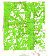
1945 Map of Clarksville
USGS Topo · Published 1960About this map
Chipola River winding through central Calhoun County anchors this mid-century landscape, characterized by the small rural settlements and schoolhouses that defined the Florida Panhandle during the 1940s. The community of Clarksville sits at the intersection of local routes, while smaller hubs like Rollins Corner and Abe Springs show the dispersed pattern of timber and agricultural life. Educational and religious landmarks were the social glue of the era, seen in the presence of Carr Sch, Crossroads Sch, and the Travelers Rest Ch, which also served as a school site. The map traces numerous watercourses including Fourmile Creek and Tenmile Creek, highlighting the intricate drainage system feeding into the river. For genealogists, the inclusion of family-associated landmarks like Barfield Cem and Fisher Corner provides essential location data for tracing ancestral homesteads and community footprints before later development patterns took hold.
Find a feature on this map
38 named features on this map. Tap any name to fly to it.
Don’t see what you’re looking for? This feature index may not catch every label — zoom into the map to look around manually.
Map Details
Editions of this 1945 Clarksville Map
2 editions found
Other maps of this area

1944 · Clarksville
USGS Topo · 1:31,680

1945 · Juniper Creek
USGS Topo · 1:31,680

1945 · Blountstown
USGS Topo · 1:31,680

1945 · Clarksville
USGS Topo · 1:31,680

1945 · Broad Branch
USGS Topo · 1:31,680

1945 · Estiffanulga
USGS Topo · 1:31,680

1945 · Frink
USGS Topo · 1:31,680

1952 · Alford SE
USGS Topo · 1:24,000

1952 · Altha West
USGS Topo · 1:24,000

1952 · Altha East
USGS Topo · 1:24,000