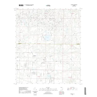
2018 Map of Alford SE
USGS Topo · Published 2018About this map
Camps Head Cem and Pippen Cem sit within a landscape defined by an intricate network of wetlands and ephemeral water bodies in northern Florida. This region is characterized by a high density of named ponds and creeks, such as the prominent Seventeenmile Pond and the winding Econfina Cr. The terrain includes distinctive features like Briar Head and Carmichael Head, which rise above the surrounding swampy lowlands and creeks.
Find a feature on this map
129 named features on this map. Tap any name to fly to it.
Don’t see what you’re looking for? This feature index may not catch every label — zoom into the map to look around manually.
Map Details
Editions of this 2018 Alford SE Map
This is the sole edition of this map. No revisions or reprints were ever made.
Other maps of this area

1944 · Clarksville
USGS Topo · 1:31,680

1945 · Juniper Creek
USGS Topo · 1:31,680

1945 · Clarksville
USGS Topo · 1:31,680

1945 · Fountain
USGS Topo · 1:31,680

1952 · Oakdale
USGS Topo · 1:24,000

1952 · Kynesville
USGS Topo · 1:24,000

1952 · Alford SE
USGS Topo · 1:24,000

1952 · Altha West
USGS Topo · 1:24,000
1952 · Compass Lake
USGS Topo · 1:24,000
1952 · Alford
USGS Topo · 1:24,000