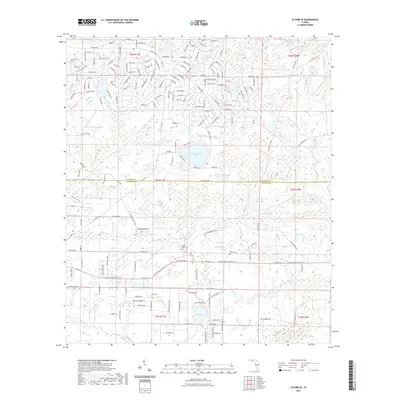
2021 Map of Alford SE
USGS Topo · Published 2021About this map
Camps Head Cem and Pippen Cem lie near the crossing of Pippin Branch and the Flanders Cutoff, marking the local heritage of this rural landscape where Jackson County meets Calhoun County. The terrain is defined by a complex network of wetlands and namesake water bodies, from the prominent Seventeenmile Pond and Blue Pond to the meandering course of Econfina Creek. The Florida National Scenic Trail traverses the southern half of the quadrangle, passing near Carmichael Head and Briar Head. These features, alongside the localized aviation presence of Maran Airport, reveal a region where traditional land use and conservation corridors intersect. The grid of residential roads like Nortek Blvd and Lake Shore Blvd north of Mossy Pond illustrates modern rural development patterns amidst established Florida wetlands.
Find a feature on this map
100 named features on this map. Tap any name to fly to it.
Don’t see what you’re looking for? This feature index may not catch every label — zoom into the map to look around manually.
Map Details
Editions of this 2021 Alford SE Map
This is the sole edition of this map. No revisions or reprints were ever made.
Other maps of this area

1944 · Clarksville
USGS Topo · 1:31,680

1945 · Juniper Creek
USGS Topo · 1:31,680

1945 · Clarksville
USGS Topo · 1:31,680

1945 · Fountain
USGS Topo · 1:31,680

1952 · Oakdale
USGS Topo · 1:24,000

1952 · Kynesville
USGS Topo · 1:24,000

1952 · Alford SE
USGS Topo · 1:24,000

1952 · Altha West
USGS Topo · 1:24,000
1952 · Compass Lake
USGS Topo · 1:24,000
1952 · Alford
USGS Topo · 1:24,000