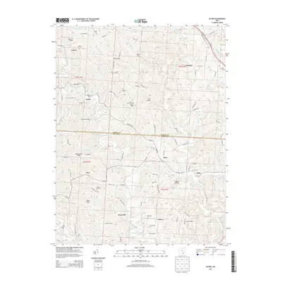
2013 Map of Alfred
USGS Topo · Published 2013About this map
E Br Shade River and its numerous tributaries, including Middle Br Shade River and Pratts Fork, carve through this section of the southeastern Ohio landscape. The area is defined by a series of named ridges and hollows, such as Coolville Ridge, Jasper Hill, and Palk Hollow, which have influenced the development of small settlements like Alfred, Sumner, and Garden. These communities are connected by a network of country roads, including Us 50 in the north and Oh-681 passing through the center.
Find a feature on this map
109 named features on this map. Tap any name to fly to it.
Don’t see what you’re looking for? This feature index may not catch every label — zoom into the map to look around manually.
Map Details
Editions of this 2013 Alfred Map
This is the sole edition of this map. No revisions or reprints were ever made.
Other maps of this area

1903 · Athens
USGS Topo · 1:62,500

1904 · Chesterhill
USGS Topo · 1:62,500

1905 · Athens
USGS Topo · 1:62,500

1906 · Chesterhill
USGS Topo · 1:62,500

1907 · Pomeroy
USGS Topo · 1:62,500

1907 · Keno
USGS Topo · 1:62,500

1947 · Columbus
USGS Topo · 1:250,000

1949 · Clarksburg
USGS Topo · 1:250,000

1956 · Clarksburg
USGS Topo · 1:250,000
1960 · Alfred
USGS Topo · 1:24,000