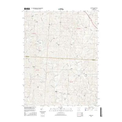
2016 Map of Alfred
USGS Topo · Published 2016About this map
Jasper Hill and Dutch Ridge define the upland topography of this Meigs County and Athens County borderland. The landscape is deeply dissected by the Middle Br Shade River and E Br Shade River, creating a network of ridges and hollows such as Dog Hollow and Palk Hollow. Small rural settlements like Alfred, Sumner, and Garden are connected by a dense system of township and county roads, reflecting the agricultural and residential patterns of the early 21st century. Genealogists will find a high concentration of burial sites, including Saint Johns Cem, Bishop Cem, and Orange Cem, often located adjacent to small crossroads or tucked away on high ground like Bearwallow Ridge. The presence of the Miller Airport near Sumner and the Blackwood Bridge over the Middle Br Shade River marks the region's transportation infrastructure, while labels like Bucks Mill and Meigs point to localized historic centers of activity.
Find a feature on this map
121 named features on this map. Tap any name to fly to it.
Don’t see what you’re looking for? This feature index may not catch every label — zoom into the map to look around manually.
Map Details
Editions of this 2016 Alfred Map
This is the sole edition of this map. No revisions or reprints were ever made.
Other maps of this area

1903 · Athens
USGS Topo · 1:62,500

1904 · Chesterhill
USGS Topo · 1:62,500

1905 · Athens
USGS Topo · 1:62,500

1906 · Chesterhill
USGS Topo · 1:62,500

1907 · Pomeroy
USGS Topo · 1:62,500

1907 · Keno
USGS Topo · 1:62,500

1947 · Columbus
USGS Topo · 1:250,000

1949 · Clarksburg
USGS Topo · 1:250,000

1956 · Clarksburg
USGS Topo · 1:250,000
1960 · Alfred
USGS Topo · 1:24,000